New Paper Published: Arabian Sea Marine Heatwaves Fuel Extreme Monsoon Rain
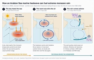 How a short-lived Arabian Sea marine heatwave can fuel extreme monsoon rain. Conceptual schematic, not to scale.
We are delighted to share that a new paper led by D. L. Suhas, a postdoctoral researcher in the group co-mentored by Weiqing Han and Aneesh Subramanian, has been published in the American Meteorological Society journal Journal of Climate. The study, “Marine Heatwaves in the Arabian Sea: Drivers and Impacts on Atmospheric Circulation and Extreme Precipitation,” asks what switches these ocean extremes on during the Indian summer monsoon, and what they do to the weather once they exist. It is the first study to link Arabian Sea marine heatwaves to extreme rainfall over the Indian subcontinent.

Why Arabian Sea Heatwaves Matter
A marine heatwave is a spell of at least five days during which sea surface temperature (SST) stays above the 90th percentile for that time of year. Marine heatwaves are best known for bleaching corals and disrupting fisheries, but they can also feed back on the weather above them. The Arabian Sea sits directly upwind of India during the June–September summer monsoon and is a major moisture source for monsoon rain, a lifeline for nearly a billion people. Until now, though, little was known about what drives individual Arabian Sea heatwaves, or whether they change monsoon rainfall and its extremes.
The team combined satellite SST (NOAA OISST, 1982–2023), atmospheric and ocean reanalyses (ERA5 and ECCO), satellite winds (CCMP) and rainfall (IMERG), 24 high-resolution CMIP6 climate models, and paired experiments with the Weather Research and Forecasting (WRF) model.
Two Emerging Hotspots
Over 1982–2023, the eastern and northern Arabian Sea stand out across the North Indian Ocean for rapid increases in summer heatwave frequency, duration and cumulative intensity. The pattern closely mirrors where the sea surface has warmed fastest, and anthropogenic warming explains a large part of that trend. Against a fixed baseline, a steadily warming ocean drifts towards a near-permanent “heatwave”, so the authors removed the long-term trend at every grid point before identifying events. That step isolates the transient extremes from the rising background, so the drivers and impacts of individual events can be studied.
What Switches a Heatwave On
On the detrended record, most heatwaves are brief. Of the 32 events found in the eastern Arabian Sea and 29 in the northern Arabian Sea during June–September, 25 in each region lasted 20 days or less, with a median duration of about nine days. Short and long events turn out to have different causes:
- Short heatwaves are set off by the boreal summer intraseasonal oscillation (BSISO), the pulse of wet and dry spells that travels north across South Asia every few weeks during the monsoon. During the BSISO’s suppressed-convection phase, skies clear, so more sunlight reaches the sea, while the southwesterly monsoon winds slacken, so less heat is lost to evaporation. A mixed-layer heat budget shows that these two surface fluxes contribute comparably to the warming, with ocean advection and weakened mixing adding to it, especially in the northern Arabian Sea. When the 10–90-day variability is filtered out of the SST record, every short heatwave disappears.
- Long heatwaves depend on year-to-year warm anomalies. El Niño and a positive Indian Ocean Dipole account for a large share of these, but other interannual variability, not yet identified, matters about as much. The two strongest long events had different origins: the 2023 heatwave largely vanishes once the warming trend is removed, whereas the 2020 northern Arabian Sea event survives detrending and is driven by interannual variability.
The Ocean Talks Back
A few days after a heatwave peaks, a low-level cyclonic circulation (an anticlockwise swirl of winds near the surface) forms over the warm water, bringing convection and rain over the sea. Its clouds cut off the sunshine and its strengthened winds raise evaporation, which together cool the sea and end the heatwave.
Is that cyclone just the next phase of the BSISO, or does the warm water create it? The authors compared BSISO events that produced a heatwave with otherwise similar events that did not. Before the SST peak, the winds in the two groups look alike. After the peak, a pronounced cyclone appears only when a heatwave is present. The WRF experiments confirm it: forced with the observed heatwave SSTs, the model develops the cyclone and its rainfall, while an otherwise identical run with climatological SSTs does not. The circulation is a response to the marine heatwave itself, not an amplified BSISO.
Where the Rain Lands
The cyclone’s position decides who gets the rain:
- Eastern Arabian Sea heatwaves. Westerly winds on the cyclone’s southern flank drive moisture onto the southern Western Ghats, while offshore winds on its northern flank leave the coast farther north drier. Extreme rain (a day above the 95th percentile of monsoon-season rainfall) becomes two to three times as likely near Kerala during BSISO events that come with a heatwave than during BSISO events without one.
- Northern Arabian Sea heatwaves. Onshore flow raises rainfall along the central west coast of India and over northwest India and Pakistan, where the risk of extreme rain also rises two- to threefold.
The 2022 Pakistan Floods
The August 2022 floods in Pakistan affected some 33 million people and caused nearly 1,500 deaths. Earlier work linked them to the triple-dip La Niña (Jeong et al., 2023), concurrent atmospheric heatwaves over China and Europe (Hong et al., 2023), and atmospheric rivers (Nanditha et al., 2023). This paper adds a marine piece to that puzzle. A heatwave in the northern Arabian Sea peaked on 8 August 2022. Over the following days a low-level cyclone formed over the warm water, with heavy rain, and then moved inland over Pakistan. The most intense two-day rainfall, on 17–18 August, coincided with the cyclone’s arrival.
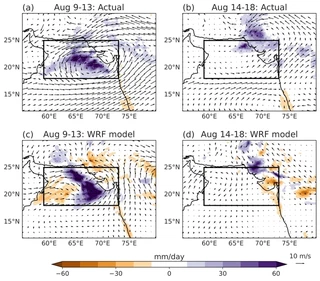
In the WRF simulations, the strong cyclone and the inland rainfall appear only when the heatwave’s warm SSTs are included, although the simulated and observed details differ. The close match between this event and the average heatwave response suggests that northern Arabian Sea heatwaves can trigger similar extremes over northwest India and Pakistan in a warming climate.
Toward Early Warnings
Heatwave-linked rainfall along India’s west coast and over northwest India and Pakistan has intensified in recent years, faster than monsoon rainfall overall. The record is still too short to say how much of that comes from climate change and how much from natural variability. The result also offers a route to prediction. BSISOs are among the more predictable features of the monsoon, with useful forecast skill weeks ahead. Because they set off most Arabian Sea heatwaves, the authors argue that forecasting the heatwaves themselves is within reach. Such forecasts could warn of elevated extreme-rain risk along the west coast of India and over northwest India and Pakistan days in advance, supporting flood preparedness as well as protecting marine ecosystems.
Aneesh Subramanian’s contribution was supported by NASA (21-OSST21-0026), the U.S. Department of Energy (DE-SC0024263) and the Office of Naval Research ASTraL initiative (N00014-23-1-2092); the group’s related projects are listed on our projects page.
A Collaborative Effort
The study was coauthored by:
- Dr. D. L. Suhas, Dr. Weiqing Han, Dr. Aneesh C. Subramanian and Dr. Michael Alexander: University of Colorado Boulder
- Dr. Toshiaki Shinoda: Texas A&M University–Corpus Christi
- Dr. Rui Sun: Scripps Institution of Oceanography, UC San Diego
- Dr. Mark Bourassa: Florida State University and its Center for Ocean-Atmospheric Prediction Studies (COAPS)
Congratulations to Suhas and the entire team on this publication!
Read the paper: Journal of Climate · preprint on arXiv · publication page
